Cycling
There are many cycle routes both around the estate and the local area.
There are several cycle routes on the Cotswold Water Park website and several more on the Routeyou website.
Here are a couple of routes recommended by homeowners.
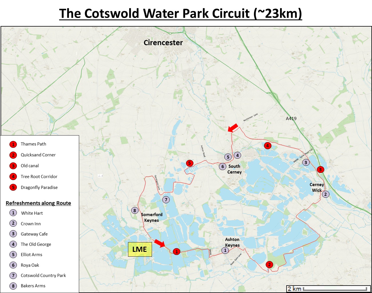
Cotswold Water Park Circuit
Effort-wise this is a moderate-grade cycle route that is ideal for adults who want to put their foot down and have a couple of hours’ workout on a bike. This route can also be undertaken at a more leisurely pace by an activity-orientated teenage family. Grade-wise this is a simple, largely off-road route that any confident cyclist will be able to complete with ease in good weather, although it does get more of a challenge during wet times.
The route can be tackled in either direction, but for those wanting to quench their thirst at the end with some alcoholic or other refreshments, then taking the anticlockwise direction so that you end up at the Bakers Arms in Somerford Keynes is recommended. The description below takes this direction.
Start the route at the entrance gate to the Lower Mill Estate and go right, SE along the gravel track, following the flow of the River Thames to Ashton Keynes. At the intersection with the B4696, turn right and follow this quiet road for ~150m before turning left into the village of Ashton Keynes. There are several small roads that cut through the village before intersecting with Rixon Gate Lane and the village cricket ground. Turn into the cricket field and follow the perimeter around to the right until you pick up a track leading to a small copse and beyond, back in the Cotswolds Water Park.
The track cuts between two lakes and then into an open field area that can be full of insects and meadow flowers in the late Spring and Summer months. However, in the winter months, this area is prone to shallow flooding. The track itself can also be a bit of a challenge for 100m where bikes with narrow tires will sink into loose gravel.
Beyond here the route follows various tracks that mark the southern boundary of the Cotswolds Water Park. Whilst the tracks are safe and well-defined, it is advisable not to stray from these marked paths as in some areas (2 – Quicksand Corner), loose unconsolidated sand beneath a thin veneer of vegetation acts as ‘quicksand’. The part of the route also takes you along the side of Manorbrook Lake where you can watch students at a waterski school in action. 4.7km after Quicksand Corner and you pass the second (Crown Inn) of the six pubs located along this route, which is useful for those needing a pit stop. If you can wait for another 1.25km, we recommend trying the Gateway Café.
Just past the Crown Inn, the road crosses a disused and largely overgrown canal. Take the path northwards that follows along the side of this canal up to the Gateway Café and Cotswold Camping store. Continue northwards under a bridge of the B4696 (Spine Road East), and past several disused locks. The path is still following the canal but now it passes through a small wooded area where the tree roots can be a challenge for those not confident in riding over them.
Before almost completely disappearing, the canal passes South Cerney golf course on the other side before intersecting with Northmoor Lane. Take a left onto this lane, quickly followed by another left back towards South Cerney village. After passing two more pubs (The Old George and Elliot Arms) the road comes to a T-junction. Turn right, passing a Co-Op food store after 50m followed by a Royal Oak in another 100m.
As you start to exit the village, the road bends round to the right. However, continue straight into the village sports playing fields. At the far end of this recreational area, is some raised ground that has been made into a BMX cycle course. The route you are following is developed to the left side of this BMX cycle course. Pass through a couple of gates and cross straight across a country lane (Ashton Road) into a fenced track cutting across meadow fields. Due to this fencing, you can’t deviate off the route although it does wind its way through some overgrown areas and some small lakes that are a paradise for insects (5 – Dragonfly Paradise) and wildfowl.
The path eventually takes you to a large gravel extraction site that is still active. Turn left, on a well-developed path and follow it as it curves around the margin of the extraction site. This path takes you to the northern margin of the Cotswold Country Park and Beach, which on hot summer days will be just as busy as a Mediterranean beach. Those in need of ice cream or soft drinks can find supplies in the park café. Otherwise, turn right Spratsgate Lane, followed by a left in 400m. This country lane will take you to Somerford Keynes and the Bakers Arms.
For those wishing to get back to LME just follow the village road until it intersects with the main road of Spine Road west and the entrance to the Lower Mill Estate on the other side.
More Cycle Routes
Thanks to LMEHA member Steven Wasley for his four cycling routes below, starting with a challenging 100km ride. For the less ambitious, scroll down for 50, 28, and 10km rides.
View the More Cycle Routes page
There are links are to the routes on both Komoot and Strava apps.
More Cycle Routes
Thanks to LMEHA member Paul Hawkins for the suggestions below. Click on the links for full details, including a map and description of the route.
View the road cycle route page.

Cycling around the estate and the area
